Caribbean region
The Lesser Antilles are highly exposed to hydro-meteorological hazards, particularly marine submersion. These volcanic islands, surrounded by deep waters and located along cyclonic tracks, are subject to extreme conditions, including severe storm surges, as illustrated during the intense 2017 hurricane season. On 19 September 2017, Hurricane Maria produced a maximum water level of 0.71 m at the Pointe-à-Pitre tide gauge. In addition, it generated offshore waves up to 8 m (Report CATNAT – Météo-France), and the BRGM post-event survey recorded laisses de mer extending up to 100 m inland from the shoreline in the Sainte-Anne region, indicating significant marine intrusion. Within the framework of the Climate Change and Consequences in the Caribbean program (C3AF), sensors were deployed in the Sainte-Anne region of Guadeloupe during Hurricane Maria to monitor wave conditions (forereef and lagoon) and to record cyclone-induced flooding using an emergent sensor on Bourg Beach. These observations provide key insights into the hydrodynamic processes driving submersion and allow quantification of the relative contributions of atmospheric storm surge and wave setup. A numerical modeling approach, calibrated and validated against field observations, was implemented to investigate the respective contributions of atmospheric storm surge and wave forcing. At the island scale, a large-domain model captures the overall storm surge and wave setup, but it is only at the local scale, using the phase-resolving wave model SWASH, that the critical role of infragravity waves is revealed. These long-period waves dominate near the coastline and significantly drive coastal flooding through wave runup processes.
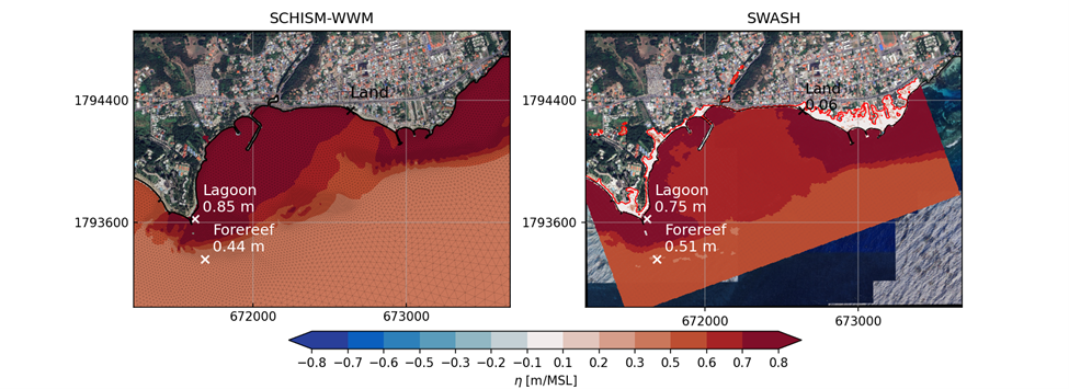
Maximum water level during the passage of cyclone Maria at Sainte Anne simulated using a phase-averaged approach (left) and a phase-resolved approach (right).
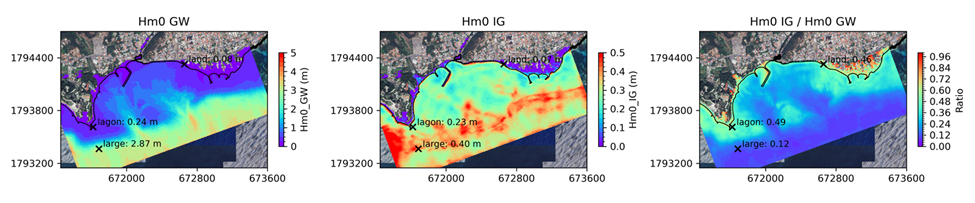
Significant wave heights (left), infragravity waves (IG, centre) and the ratio between the two, showing the strong dominance of IG waves at the coast.
FUTURISKS focuses on Guadeloupe, Martinique, and Saint Martin, where reconstructions of past flooding events, chains of impacts, and an assessment of implemented adaptation policies and measures are being carried out, with a focus on Nature-based Solutions and relocation. Crisis management exercises are also being conducted, especially in Saint Martin.