Assessing the future habitability of the atolls (WP1, WP3, WP4 ; PhD of Mirna BADILLO, BRGM, LIENSs)
Badillo-Interiano, M., Rohmer, J., Le Cozannet, G., and Duvat, V. Assessing atoll island future habitability in the context of climate change using Bayesian networks, EGUsphere [preprint], https://doi.org/10.5194/egusphere-2024-3884, 2025.
Atoll islands are threatened by multiple climate change impacts, such as sea-level rise, extreme sea-level events, ocean warming, and acidification. A recent approach to assessing climate change risk to these islands is to use multi-criteria expert judgment methods. These approaches can serve as a basis for the development of Bayesian Networks (BNs) 10 integrating expert knowledge and uncertainties to perform climate risk assessments. Here, we use the multi-criteria expert-based assessment of Duvat et al. (2021), who assessed future risk to habitability for four Indian and Pacific Oceans’ atoll islands, in order to discuss the advantages and limitations of the BN model. Advantages of the approach include the explicit treatment of uncertainties and the possibility to query expert knowledge in a non-trivial manner. For example, expert knowledge can be used to assess risks to habitability and future uncertainties and to explore inverse problems such as which 15 drivers can exceed specific risk thresholds. Our work suggests that BN, though requiring a certain level of implementation expertise, could be used to assess climate change risk and support climate adaptation.
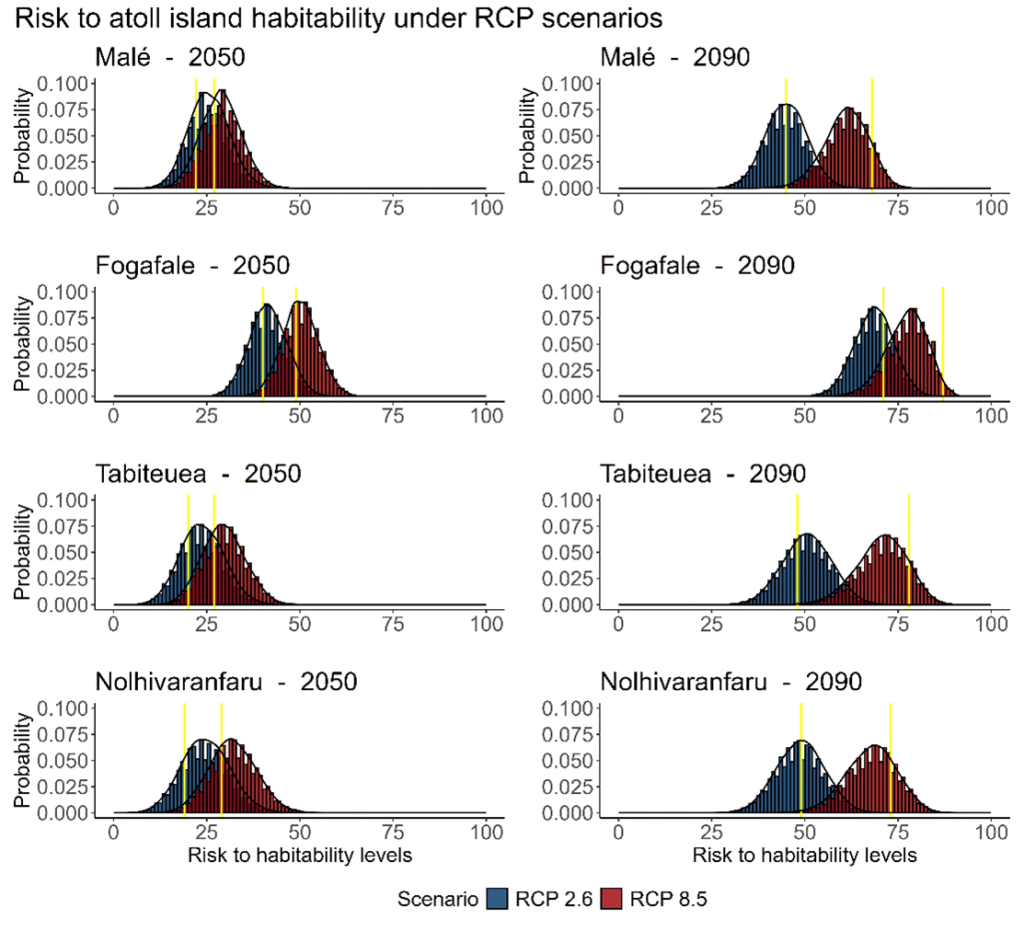
Probability of the risk to habitability under the RCP 2.6 and RCP 8.5 scenarios in 2050 and 2090 for the four islands. In 2050, Malé, Tabiteuea, and Nolhivaranfaru show low to moderate risk, slightly higher under the RCP 8.5. In contrast, the risk to habitability is higher for Fogafale than for the other islands. In 2090, the risk remains low to moderate under RCP 2.6 except for Fongafale (moderate to high). In the RCP 8.5 scenario, all islands could experience moderate to high risk levels.
Spatio-temporal analysis of the main meteo-oceanic forcing (WP1)
Santamaría-Gómez, A., Boy, J.-P., Feriol, F., Gravelle, M., Loyer, S., Nahmani, S., Nicolas, J., García Pallero, J. L., Panetier, A., Pollet, A., and Sakic, P.: Monitoring the Earth’s deformation with the SPOTGINS series, Earth Syst. Sci. Data Discuss. [preprint], https://doi.org/10.5194/essd-2025-223, in review, 2025.
In order to separate the different contributions to tide gauge observations, one of the objectives of Task 1.1 was to obtain estimates of vertical motions of the Earth’s crust at the coast. As a first step, data from nearly 120 permanent GNSS stations located in coastal areas of France’s oversea territories were calculated using the new processing chain from the SPOTGINS collaborative project (https://ac-gnss.pagelab.univ-lr.fr/spotgins ). The position time series were then analyzed to derive variables of interest such as vertical velocity (i.e. the rate of change of the station’s vertical position). These results were supplemented by a vertical motion product derived from radar interferometry (InSAR). The European Ground Motion Service (EGMS) products were reworked to provide spatial information for the regions covered by the portal: Guadeloupe, Martinique, Saint Martin, Réunion and Mayotte. Analysis of the GNSS data for Mayotte has highlighted the subsidence of around 20 centimeters associated with the formation of the Fani Maoré submarine volcano between 2018 and 2021. This subsidence is reflected in a rise in the relative mean sea level recorded by the Dzaoudzi tide gauge (Figure 2).
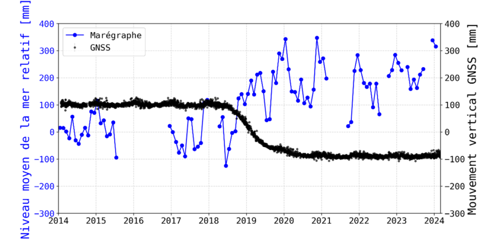
Monthly mean sea level at Dzaoudzi tide gauge (Mayotte, in blue) and vertical position time series from the permanent GNSS station located on the tide gauge (in black).
A new wave hindcast for the tropical ocean (WP1 ; PhD of Axelle GAFFET, LIENSs)
Gaffet, A., Bertin, X., Sous, D., Michaud, H., Roland, A., and Cordier, E., 2025a. A new global high-resolution wave model for the tropical ocean using WAVEWATCH III version 7.14. Geoscientific Model Development 18, 1929–1946, https://doi.org/10.5194/gmd-18-1929-2025, 2025.
Global wave models used to study wave climates generally use a spatial resolution of the order of several tens of km, which does not allow islands and archipelagos to be explicitly represented. The effect of islands and archipelagos on wave propagation is traditionally represented using obstruction mask techniques, which can lead to strong negative biases for archipelagos located in the tropical ocean, such as French Polynesia or Indonesia. In order to overcome this problem, a global wave model using a single unstructured grid, in which all islands larger than 3 km are explicitly represented and whose spatial resolution varies from 50 km offshore to 100 m at the coast on certain tropical islands, has been developed. This model is forced by ERA5 wind fields for which a quantile/quantile correction has been applied (Gaffet et al., 2025a). The two objectives of this innovative and ambitious modelling strategy are : (1) to explicitly represent all islands larger than 3 km and thus improve sea state forecasting around archipelago, and (2) to accurately simulate sea states from the deep ocean to within a few hundred metres of the coast and thus enable direct comparisons with available measurements, which are often located very close to the coast. Compared to conventional approaches, this new modelling strategy makes it possible to reduce the strong negative biases on wave heights on tropical islands and thereby to reduce the error on wave heights by a factor of 2 or even 3 compared to regular grids with obstruction masks.
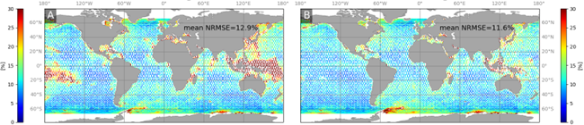
Root mean square error of significant wave height for 2007 between spatial altimetry data and (A) a conventional configuration of the WaveWatchIII model using a regular 0.5° grid and (B) with our unstructured grid explicitly representing the islands, which shows a reduction in errors by a factor of 2 to 3 in tropical archipelagos such as French Polynesia (from Gaffet et al., 2025a).
Extreme waves near the coast : the contribution of tropical cyclones (WP1 ; Ifremer)
Jullien S., Aucan J., Kersternare E., Lengaigne M., Menkes C., 2024. Unveiling the global influence of tropical cyclones on extreme waves approaching coastal areas. Nature Communications 15: 6593. https://doi.org/10.1038/s41467-024-50929-2
Despite the progress made in the study by Gaffet et al (2025), the resolution of the wind fields used (0.5°) does not allow tropical cyclones and the resulting waves to be represented. One of the main challenges is the poor representation of cyclones in existing global models, and a lack of observations, which limits the assessment of their contribution to extreme waves. To address this challenge, we have designed and produced sea-state simulations, with and without taking into account the realistic winds associated with cyclones, in order to assess their contribution on a global scale. The results show that tropical cyclones are responsible for a major part of extreme waves in tropical regions (35 to 50% on average, and up to 100% in the most exposed areas such as the north-west Pacific). Their influence also extends to regions without cyclones, such as the equatorial Pacific, where around 30% of extreme wave events are linked to cyclones formed elsewhere. Climate variability from one year to the next (known as inter-annual variability) can locally amplify these hazards, modifying their frequency and intensity. This is the case, for example, during El Niño episodes in the Central Pacific, and during La Niña episodes in the West Indies and southern Indian Ocean territories. These results provide essential knowledge for managing coastal risks and preparing for extreme climate hazards.
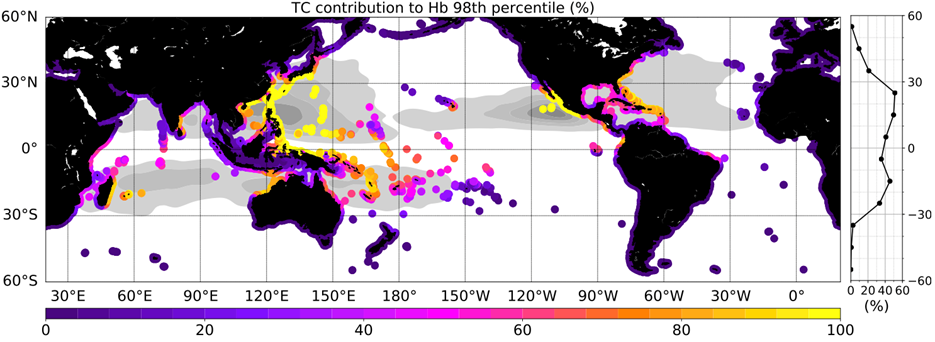
Contribution of tropical cyclones (in %) to extreme waves approaching coastal areas (Figure taken from Jullien et al. 2024).
Extreme sea levels and submersions associated with past major events (WP1 ; PhD of Aline ZRIBI, LIENSs, IFREMER ; Lola ORMIERES, LIENSs ; Axelle GAFFET, LIENSs)
Zribi, A., Jullien, S., Dodet, G., Bertin, X. et Herry, N., 2025. Sensitivity of storm surge modeling to the representation of atmospheric forcing: the case study of hurricane Irma. Proceedings of the 10th conference Coastal Dynamics, Aveiro, Portugal, 7-11 April 2025.
In early September 2017, Hurricane Irma crossed the French West Indies, generating exceptional surges (abnormal rises in sea level), such as the one measured in Saint-Martin (~1.8m), and major impacts on the territories. We have explored how the uncertainties associated with the hurricane’s intensity, size, trajectory and wind structure influence the modelling of the storm surge. The results show that the surge can vary from 30 cm to 2.6 m depending on the wind field considered (Zribi et al., 2025). Among the sources of uncertainty, those related to the intensity of the cyclone and the representation of the wind stress on the ocean surface appear to be the most critical. Uncertainties about the trajectory also play a major role, influencing both the intensity and the temporality of the surge.
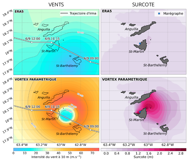
Vents cycloniques (gauche) et surcote (droite) autour de Saint-Martin dans deux simulations numériques. En haut, le modèle océanique CROCO est forcé par les vents ERA5 ; en bas, par un champ de vent reconstruit à l’aide d’une formulation paramétrique.
Ormières, L., Bertin, X., Krien, Y., Zribi, A. et Arnaud, G., 2025. Analysis of hydrodynamic processes that caused extreme sea levels in Guadeloupe during hurricane Maria (2017). Proceedings of the 10th conference Coastal Dynamics, Aveiro, Portugal, 7-11 April 2025.
The Lesser Antilles are highly exposed to meteo-oceanic hazards, particularly high waves and marine submersions associated with tropical cyclones, as illustrated by the intense 2017 hurricane season. On 19 September 2017, Hurricane Maria produced a maximum water level of 0.71 m at the Pointe-à-Pitre tide gauge in Guadeloupe and generated waves of around 8 m offshore of the archipelago (CATNAT Report – Météo-France). BRGM’s post-event survey recorded low-lying areas extending up to 100 m inland in the Sainte-Anne region. As part of the Climate Change and Consequences in the French Antilles (C3AF) programme, pressure sensors were deployed along the Sainte-Anne coastline during Hurricane Maria, to measure wave conditions at the fore-reef, in the lagoon and inland, enabling marine submersion to be quantified. These observations provide essential information on the underlying hydrodynamic processes and enable the relative contributions of atmospheric surge and wave setup to be quantified. A numerical modelling approach on the scale of the entire Guadeloupe archipelago, calibrated and validated against field data, was implemented and shows that the surge along the shore is dominated by wave setup. This simulation makes it possible to reproduce water heights accurately along the coast, but completely misses the marine submersion associated with Maria. The application of a local model at the scale of Sainte Anne Bay, in which waves are explicitly represented (phase-averaged approach), makes it possible to reproduce the submersion realistically and suggests that it is dominated by infragravity waves (long waves linked to the presence of groups in the incident waves, see analysis in WP2).
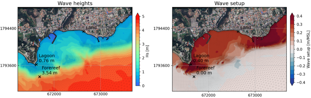
Significant wave height (left) and wave setup (right), showing that the dissipation of waves linked to cyclone Maria was the main component of the surge at Sainte Anne (Guadeloupe).
Gaffet, A., Bertin, X., Sous, D. et Cordier, E., 2025b. A modelling-based analysis of extreme wave setup in a fringing coral reef. Proceedings of the 10th conference Coastal Dynamics, Aveiro, Portugal, 7-11 April 2025.
In addition to the hazards associated with tropical cyclones, some islands may be exposed to distant long swells, as is the case for the south coast of La Réunion Island. Thanks to the national observation services DYNALIT (https://prochain.dynalit.fr/ ) and ReefTEMPS (https://www.reeftemps.science/ ), two permanent pressure sensors are deployed for several years on the reef slope and in the Hermitage Lagoon on Reunion Island. These sensors were used to measure the waves and surge associated with an exceptional distant swell that hit the south coast of La Réunion at the end of June 2022, causing significant material damage, one fatality and one serious injury.
The analysis of the data from these pressure sensors shows that this exceptional distant swell episode was characterised by significant wave heights of up to 7.5 m, generating a 1.5 m surge in the Hermitage Lagoon. This surge was driven by wave dissipation on the reef, and our numerical simulations suggest that it can only be reproduced with a 3D model that fully couples waves and hydrodynamic circulation and takes into account the effects of rollers. This represents a challenge for operational forecasting, where models are currently too coarse and do not take sufficient account of wave effects.
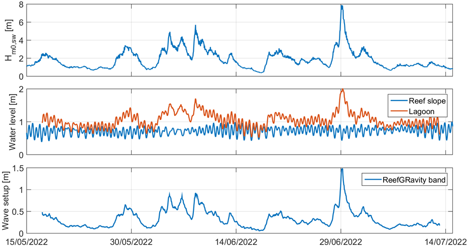
Significant wave height on the Hermitage reef (top), free surface elevation on the reef (blue) and in the lagoon (orange, centre) and the difference between the two corresponding to the wave setup (bottom), showing an exceptional value of 1.5 m.
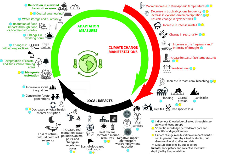
Study of the manifestations and impacts of climate change, and of the adaptation measures deployed on the ground in Touho, Northern Province, New Caledonia (WP1 ; LIENSs)
Study of the manifestations and impacts of climate change, and of the adaptation measures deployed on the ground in Touho, Northern Province, New Caledonia (Duvat et al., submitted)
Because scientific knowledge on the manifestations and impacts of climate change at the local level (here, Touho municipality) is relatively limited, it was decided to gather information by collecting Indigenous Knowledge. This work was based on close collaboration with local stakeholders (the Paicî-Cèmuhi customary area, municipality, the local environmental association, and tribes), which enabled the conduction of semi-structured interviews with key informants and the organization of focus groups.
The study confirmed a number of research hypotheses on the scientific and ethical importance of (re)valuing Indigenous Knowledge in climate change studies: (1) such an approach significantly improves our understanding of the impacts of climate change by anchoring it in history, while also contributing to the decolonization of science; (2) Indigenous knowledge is highly valuable for understanding climate change, as it reflects the highly developed observational skills of Indigenous Peoples and their experience of the climate and environment associated with their subsistence-based lifestyles; (3) it can reveal emerging risks that are not captured by conventional scientific methods.
Beyond this, this article proposes a collaborative approach to overcome existing ontological divides and thereby support the design of locally designed and led climate change adaptation.
Finally, it proposes the concept of “relational adaptation” to define adaptation in Indigenous communities: an adaptation process that places at the center of its concerns the strong relationships that populations maintain, on the one hand, with their lands and, on the other, with their communities on a transgenerational basis.
The figure below summarizes the results obtained, showing the importance of the Indigenous knowledge collected in informing the local manifestations of climate change (barely described to date by climate modeling science), its impacts (described only in a very general and uncontextualized manner by conventional scientific studies, and on a national rather than local basis), and the adaptation measures implemented in the territories.